Coastal Arctic Remote Sensing with Landsat
The objective of this project is to retrieve concentrations of chlorophyll and suspended particulate matter (SPM) in coastal arctic waters. The area of interest is located within the north slope of Alaska due to its high erosion rates and increased river discharge into the arctic ocean coastline. According to the USGS National Assessment of Coastal Change Hazards, Alaska’s north coast is mainly erosional, with 84% displaying shoreline retreat over a long-term range of the 1940s-2010s period1. These high rates of erosion and river discharge can be attributed to a multitude of factors, mainly regarding climate change. The effects of rising sea levels and thawing permafrost only adds to land loss in Arctic coastal regions2. The repercussions of these factors pose numerous ecological and national security implications. With looking into satellite data products, particularly from Landsat 8/9 data, research can be conducted through gathering suspended particulate matter change over time to analyze annual spatial variation of processed images. Remote sensing from the Landsat satellite, which uses passive sensing, allows for data collection in order to produce SPM maps to further analyze. Landsat has a Thematic Mapper sensor which is a passive type, meaning it records radiation that is reflected from the earth’s surface, usually in the form of solar energy3.
Process
In terms of the process of extracting data from Landsat, USGS Earth Explorer was used to search for particular images in the northern Alaskan coastline. Search criteria involved geographic location, as well as a date range and cloud cover. A range of Mid-July to Mid-September was selected in order to find data sets with the least amount of ice coverage, as that would affect future SPM maps. The different types of data from Landsat could be chosen on USGS Earth explorer as well, with the selected type being L1TP, meaning level 1, at the top of the atmosphere in digital counts to physical units of radians, with TP being precise terrain location, where the data is geo-corrected for each of the pixels in the images. The significance of 02 data indicates it is a reprocessed image, and T1 data was chosen for its reliable quality data. The next step was to utilize Science Toolbox Exploitation Platform (SNAP) software to process and apply algorithms to the images. The SNAP software allows for access to spectral channels from data collected from satellite imagery. A plugin named iCOR, was used in the SNAP software to atmospherically correct data from Landsat. With it, SIMilarity Environment Correction (SIMEC) was considered, where it corrects additional photons from surrounding adjacent views from Landsat’s sensors, essentially considering the sensor viewing geometry and digital elevation area model. iCOR also permitted glint correction post processing to filter out bright spots of sunlight on the earth’s surface within images. In addition, iCOR was able to estimate aerosol optical thickness (AOT), which is when light passing through the atmospheric column gets attenuated. iCOR can then take light measured from the center level of reflectance and estimate the thickness of that column, to determine how much reflected light is recorded at that sensor attributing to atmospheric interference and correcting it.
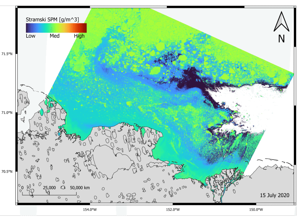
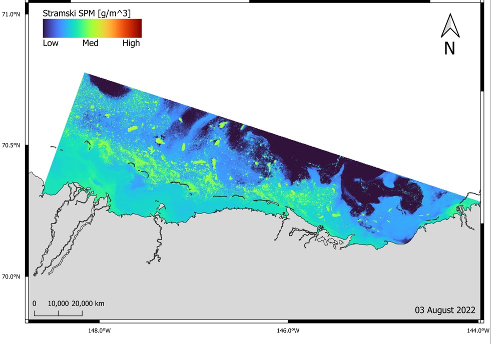
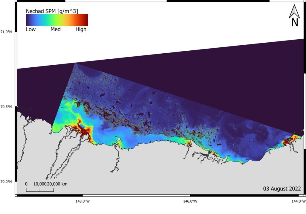
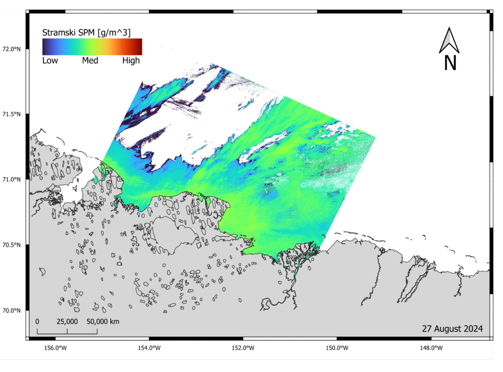
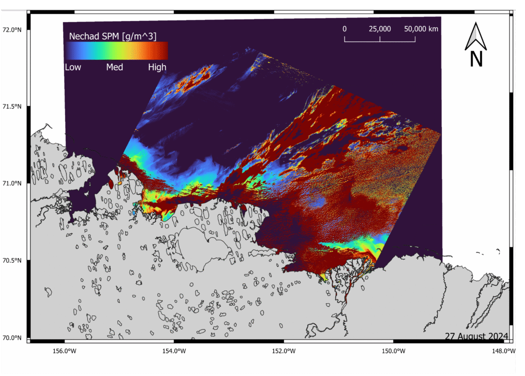
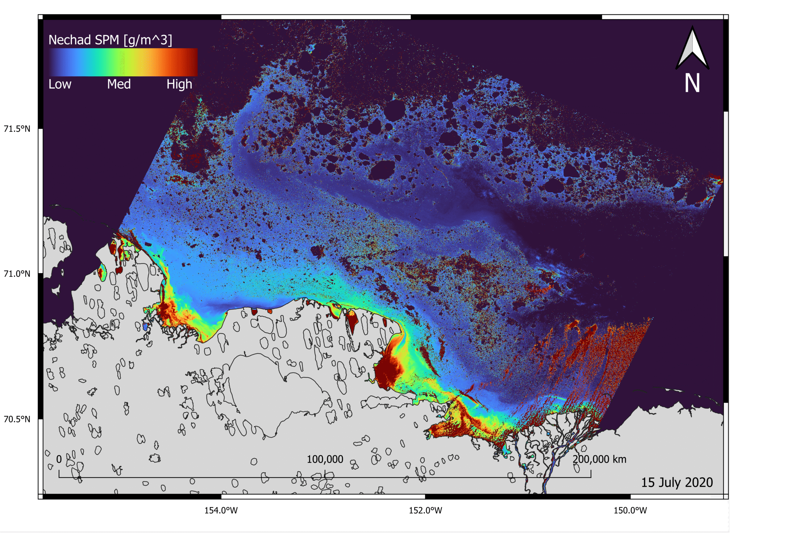
Once all the images are post-processed with the iCOR plugin on the SNAP software, two differing algorithms regarding suspended particulate matter (SPM), which was applied using the bands maths feature on SNAP. One of the algorithms (Nechad) is a total suspended matter concentration (TSM) to sediment transport algorithm that was developed for turbid waters4. The other algorithm (Stramski) used a ratio of particulate organic carbon to SPM in order to differentiate bodies of water with varying ratios of organic and mineral particles, which was done directly through spectral remote-sensing reflectance of the ocean4. This algorithm supports its conclusion, that standard algorithms overestimate particulate organic carbon in Arctic waters.
After both these algorithms were placed for images ranging from the years 2020, 2022, and 2024, the data was then formatted into an SPM map using a geographical information system (GIS) software named QGIS. On this program, a shapefile of the Alaskan area of interest was provided to line up the output of data after applying both algorithms to each data set. The data was colorized and kept constant throughout all maps in order to display bi-annual variations. The results of both algorithms on the same data set/location are in the SPM maps shown below.
1 The USGS Updated Its Shoreline-Change Rates for Alaska’s North Coast between the U.S.-Canadian Border and Icy Cape as Part of the National Assessment of Coastal Change Hazards.”
2 Creel et al., “Coastal Retreat in Alaska Is Accelerating Because of Compound Climate Impacts.”
3 “Remote Sensing: An Overview.”
4 Stramski, Constantin, and Reynolds, “Adaptive Optical Algorithms with Differentiation of Water Bodies Based on Varying Composition of Suspended Particulate Matter: A Case Study for Estimating the Particulate Organic Carbon Concentration in the Western Arctic Seas.”
Suspended Particulate Matter Maps